
Mapa topográfico Cranfield
Haga clic en el mapa para ver la altitud.
Acerca de este mapa
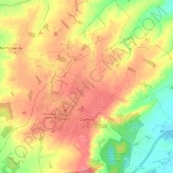
Nombre: Mapa topográfico Cranfield, altitud, relieve.
Lugar: Cranfield, Central Bedfordshire, England, United Kingdom (52.05026 -0.65807 52.11068 -0.57832)
Altitud media: 88 m
Altitud mínima: 42 m
Altitud máxima: 121 m
Otros mapas topográficos
Haga clic en un mapa para ver su topografía, su altitud y su relieve.
Dunstable Downs
United Kingdom > England > Central Bedfordshire > Church End
Because of its elevation, Dunstable Downs hosted a station in the shutter telegraph chain which connected the Admiralty in London to its naval ships in the port of Great Yarmouth during the years 1808 to 1814.
Altitud media: 178 m
Edgecote
United Kingdom > England > Central Bedfordshire > Caddington > Aley Green
Altitud media: 168 m
Houghton Hall Park
United Kingdom > England > Central Bedfordshire > Houghton Regis
Altitud media: 134 m
Totternhoe Knolls
United Kingdom > England > Central Bedfordshire > Church End > Lower End
Altitud media: 105 m
Crawley Park
United Kingdom > England > Central Bedfordshire > Aspley Guise > Husborne Crawley
Altitud media: 98 m