
Mapa topográfico La Crosse
Mapa interactivo
Haga clic en el mapa para ver la altitud.
Acerca de este mapa
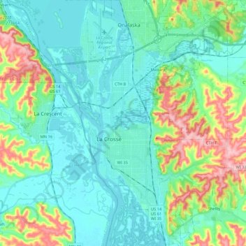
Nombre: Mapa topográfico La Crosse, altitud, relieve.
Lugar: La Crosse, La Crosse County, Wisconsin, United States (43.74602 -91.27594 43.89838 -91.15709)
Altitud media: 238 m
Altitud mínima: 188 m
Altitud máxima: 391 m
Surrounding the relatively flat prairie valley where La Crosse lies are towering 500-foot (150 m) bluffs, one of the most prominent of which is Grandad Bluff (mentioned in Life on the Mississippi by Mark Twain), which has an overlook of the three states region. This feature typifies the topography of the Driftless Area in which La Crosse sits. This rugged region is composed of high ridges dissected by narrow valleys called coulees, a French term. As a result, the area around La Crosse is frequently referred to as the "Coulee Region".
Otros mapas topográficos
Haga clic en un mapa para ver su topografía, su altitud y su relieve.
North La Crosse
United States > Wisconsin > La Crosse County > La Crosse
North La Crosse, La Crosse, La Crosse County, Wisconsin, 54603, United States
Altitud media: 197 m
Village of West Salem
United States > Wisconsin > La Crosse County > West Salem
Village of West Salem, West Salem, Town of Hamilton, La Crosse County, Wisconsin, United States
Altitud media: 226 m
Madison Court
United States > Wisconsin > La Crosse County > La Crosse
Madison Court, La Crosse, La Crosse County, Wisconsin, United States
Altitud media: 229 m
Onalaska
United States > Wisconsin > La Crosse County
Onalaska, La Crosse County, Wisconsin, United States
Altitud media: 219 m