
Haz una donación
Mapa topográfico Seneca Castle
Haga clic en el mapa para ver la altitud.
Haz una donación
Acerca de este mapa
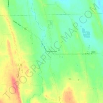
Nombre: Mapa topográfico Seneca Castle, altitud, relieve.
Altitud media: 244 m
Altitud mínima: 216 m
Altitud máxima: 279 m
Haz una donación
Otros mapas topográficos
Haga clic en un mapa para ver su topografía, su altitud y su relieve.
Town of Farmington
United States > New York > Ontario County
The land, at an average elevation of 600 feet above sea level, is compressed by the Wisconsin glaciation and slopes from an elevation of 700 feet at the southern border with the town of Canandaigua, to 500 feet at the north boundary with the town of Macedon. The land comprises drumlins and eskers. Other than…
Altitud media: 185 m
Haz una donación
Honeoye
United States > New York > Ontario County > Town of Richmond
Honeoye is located at 42°47′24″N 077°31′01″W / 42.79000°N 77.51694°W / 42.79000; -77.51694 (42.7900646, -77.5169374) and its elevation is 814 feet (248 m).
Altitud media: 268 m
Haz una donación
Haz una donación
Haz una donación
Town of Farmington
United States > New York > Ontario County
The land, at an average elevation of 600 feet above sea level, is compressed by the Wisconsin glaciation and slopes from an elevation of 700 feet at the southern border with the town of Canandaigua, to 500 feet at the north boundary with the town of Macedon. The land comprises drumlins and eskers. Other than…
Altitud media: 185 m
Haz una donación