
Haz una donación
Mapa topográfico Edmundston
Haga clic en el mapa para ver la altitud.
Haz una donación
Edmundston
Edmundston has a downhill skiing facility in the city at Mont Farlagne. This facility has 3 lifts, a t-bar, a double chair, and a quad chair. It has 14 trails and an elevation of 690 feet. Snowmaking is available. Five trails are lit for night skiing.
Haz una donación
Acerca de este mapa
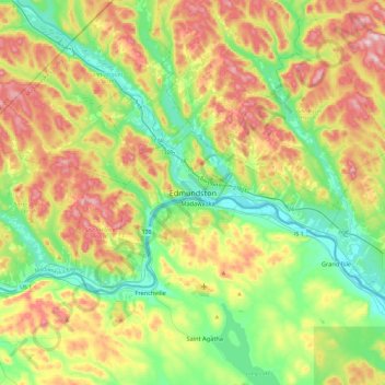
Nombre: Mapa topográfico Edmundston, altitud, relieve.
Altitud media: 220 m
Altitud mínima: 130 m
Altitud máxima: 396 m
Haz una donación
Otros mapas topográficos
Haga clic en un mapa para ver su topografía, su altitud y su relieve.
Edmundston
Canada > New Brunswick > Madawaska Parish
Edmundston has a downhill skiing facility in the city at Mont Farlagne. This facility has 3 lifts, a t-bar, a double chair, and a quad chair. It has 14 trails and an elevation of 690 feet. Snowmaking is available. Five trails are lit for night skiing.
Altitud media: 256 m