
Mapa topográfico Prats Bas
Mapa interactivo
Haga clic en el mapa para ver la altitud.
Acerca de este mapa
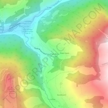
Nombre: Mapa topográfico Prats Bas, altitud, relieve.
Altitud media: 1,840 m
Altitud mínima: 1,361 m
Altitud máxima: 2,469 m
Otros mapas topográficos
Haga clic en un mapa para ver su topografía, su altitud y su relieve.
La Casse
France > Provence-Alpes-Côte d'Azur > Hautes-Alpes > Château-Ville-Vieille > Ville-Vieille
La Casse, Ville-Vieille, Château-Ville-Vieille, Briançon, Hautes-Alpes, Provence-Alpes-Côte d'Azur, France métropolitaine, 05350, France
Altitud media: 1,744 m
Le Brasq
France > Provence-Alpes-Côte d'Azur > Hautes-Alpes > Château-Ville-Vieille > Ville-Vieille
Le Brasq, Ville-Vieille, Château-Ville-Vieille, Briançon, Hautes-Alpes, Provence-Alpes-Côte d'Azur, France métropolitaine, 05350, France
Altitud media: 1,720 m