
Gracias por apoyar a este sitio ❤️
Haz una donación
Haz una donación
Mapa topográfico Ajinkyatara Fort
Haga clic en el mapa para ver la altitud.
Gracias por apoyar a este sitio ❤️
Haz una donación
Haz una donación
Ajinkyatara Fort
Ajinkyatara Fort, also known as the "Fort of the Sapta-Rishi," is a historical hill fort located on Ajinkyatara Mountain, one of the seven mountains surrounding the city of Satara in the Sahyadri Mountains of Maharashtra, India. Situated at an altitude of 3,300 feet, the fort overlooks Satara City and is considered one of the major heritage sites in Maharashtra.
Gracias por apoyar a este sitio ❤️
Haz una donación
Haz una donación
Acerca de este mapa
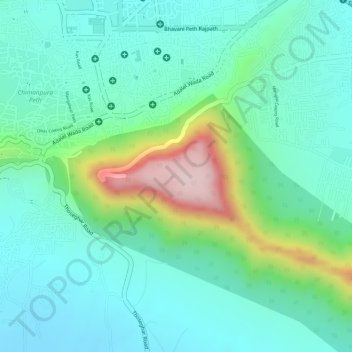
Nombre: Mapa topográfico Ajinkyatara Fort, altitud, relieve.
Altitud media: 764 m
Altitud mínima: 675 m
Altitud máxima: 1,008 m
Gracias por apoyar a este sitio ❤️
Haz una donación
Haz una donación