
Haz una donación
Mapa topográfico Normanton Le Heath
Haga clic en el mapa para ver la altitud.
Haz una donación
Acerca de este mapa
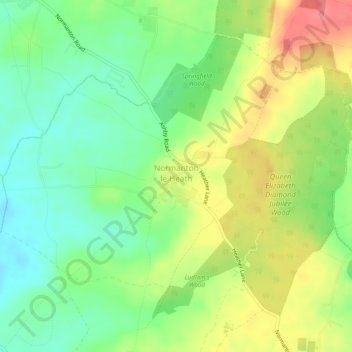
Nombre: Mapa topográfico Normanton Le Heath, altitud, relieve.
Altitud media: 123 m
Altitud mínima: 92 m
Altitud máxima: 164 m
Haz una donación
Otros mapas topográficos
Haga clic en un mapa para ver su topografía, su altitud y su relieve.
Kelham Bridge Nature Reserve
United Kingdom > England > Leicestershire > North West Leicestershire > Ravenstone
Altitud media: 139 m
Isley Walton
United Kingdom > England > Leicestershire > North West Leicestershire
Altitud media: 76 m
Haz una donación
Thringstone
United Kingdom > England > Leicestershire > North West Leicestershire
Altitud media: 126 m
Lount Wood
United Kingdom > England > Leicestershire > North West Leicestershire > Lount
Altitud media: 131 m
Breedon on the Hill
United Kingdom > England > Leicestershire > North West Leicestershire
Altitud media: 84 m
Haz una donación
Nailstone Colliery Railway
United Kingdom > England > Leicestershire > North West Leicestershire > Ibstock
Altitud media: 155 m
Long Whatton
United Kingdom > England > Leicestershire > North West Leicestershire
Altitud media: 63 m
Timberwood Hill
United Kingdom > England > Leicestershire > North West Leicestershire
Altitud media: 192 m
Haz una donación
Breedon Cloud Wood
United Kingdom > England > Leicestershire > North West Leicestershire > Breedon on the Hill
Altitud media: 90 m
Swannymote Rock
United Kingdom > England > Leicestershire > North West Leicestershire > Coalville
Altitud media: 139 m
Willesley Woods
United Kingdom > England > Leicestershire > North West Leicestershire > Ashby-de-la-Zouch > Willesley
Altitud media: 108 m
Haz una donación
Hugglescote
United Kingdom > England > Leicestershire > North West Leicestershire
Altitud media: 154 m
Bardon Hill
United Kingdom > England > Leicestershire > North West Leicestershire
Altitud media: 199 m
Ashby de la Zouch Canal
United Kingdom > England > Leicestershire > North West Leicestershire > Moira
Altitud media: 100 m
Haz una donación
Albert Village
United Kingdom > England > Leicestershire > North West Leicestershire
Altitud media: 113 m
Oaks in Charnwood
United Kingdom > England > Leicestershire > North West Leicestershire
Altitud media: 155 m
Haz una donación
Donington Le Heath
United Kingdom > England > Leicestershire > North West Leicestershire
Altitud media: 148 m
Shellbrook
United Kingdom > England > Leicestershire > North West Leicestershire > Ashby-de-la-Zouch > Blackfordby
Altitud media: 128 m
Cademan Wood
United Kingdom > England > Leicestershire > North West Leicestershire > Whitwick
Altitud media: 138 m
Haz una donación
Ashby de la Zouch Canal
United Kingdom > England > Leicestershire > North West Leicestershire > Oakthorpe
Altitud media: 97 m
Peggs Green
United Kingdom > England > Leicestershire > North West Leicestershire > Peggs Green
Altitud media: 121 m
Farmtown
United Kingdom > England > Leicestershire > North West Leicestershire > Coleorton
Altitud media: 141 m
Haz una donación
Sence Valley Country Park
United Kingdom > England > Leicestershire > North West Leicestershire > Coalville > Heather
Altitud media: 131 m
Haz una donación
Isley Walton
United Kingdom > England > Leicestershire > North West Leicestershire
Altitud media: 76 m