
Mapa topográfico Reichertsheim
Haga clic en el mapa para ver la altitud.
Acerca de este mapa
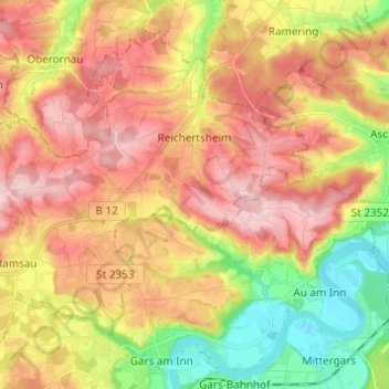
Nombre: Mapa topográfico Reichertsheim, altitud, relieve.
Altitud media: 512 m
Altitud mínima: 405 m
Altitud máxima: 603 m
Otros mapas topográficos
Haga clic en un mapa para ver su topografía, su altitud y su relieve.
Mühldorf am Inn
Deutschland > Bayern > Landkreis Mühldorf am Inn > Mühldorf a. Inn > Mühldorf am Inn
Altitud media: 402 m
Leoprechting
Deutschland > Bayern > Landkreis Mühldorf am Inn > Niedertaufkirchen
Altitud media: 466 m
Hofthambach
Deutschland > Bayern > Landkreis Mühldorf am Inn > Neumarkt-Sankt Veit > Wiesbach
Altitud media: 475 m
Zaismaier
Deutschland > Bayern > Landkreis Mühldorf am Inn > Stefanskirchen > Zaismaier
Altitud media: 447 m
Heisting
Deutschland > Bayern > Landkreis Mühldorf am Inn > Kraiburg > Frauendorf
Altitud media: 412 m
Oberwiesbach
Deutschland > Bayern > Landkreis Mühldorf am Inn > Neumarkt-Sankt Veit > Wiesbach
Altitud media: 480 m
Schloss Teising
Deutschland > Bayern > Landkreis Mühldorf am Inn > Neumarkt-Sankt Veit > Teising
Altitud media: 461 m
Schloss Guttenburg
Deutschland > Bayern > Landkreis Mühldorf am Inn > Kraiburg > Frauendorf
Altitud media: 427 m