
Haz una donación
Mapa topográfico Bathwick Hill
Haga clic en el mapa para ver la altitud.
Haz una donación
Bathwick Hill
Number 1 (Bathwick Lodge) is a 2-storey villa with a steep Mansard room, built in 1825, extended in 1840 and the late C19. Probably by John Pinch the Elder.[4] Number 2 is from the early 19th century and has shutters over the windows.[11] Number 3 includes a porch which is elaborately enriched with carving, Neo-Grecian gate posts and wrought iron gates.[12] Number 4 has a parapet which sweeps up to central balustrade with a rococo flourish,[13] as does number 5 which is also known as Cornwall Lodge.[14] Number 6, which is also known as Willow House, includes a wrought iron verandah on the 1st floor. Number 7 has a shallow hipped roof.[15] Number 8 has also been known as Upsala Villa[16] and later as Mendip Lodge.[17] The road elevation of number 9, built in 1820, extended in 1870, presents half an octagon in plan with overhanging eaves.[18]
Haz una donación
Acerca de este mapa
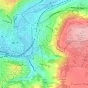
Nombre: Mapa topográfico Bathwick Hill, altitud, relieve.
Altitud media: 93 m
Altitud mínima: 16 m
Altitud máxima: 208 m
Haz una donación
Otros mapas topográficos
Haga clic en un mapa para ver su topografía, su altitud y su relieve.