
Mapa topográfico Rastede
Mapa interactivo
Haga clic en el mapa para ver la altitud.
Acerca de este mapa
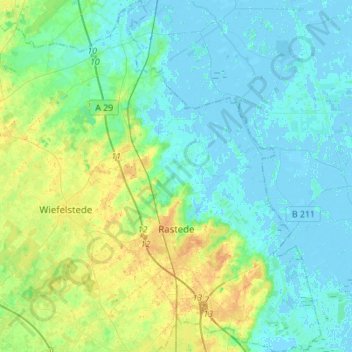
Nombre: Mapa topográfico Rastede, altitud, relieve.
Lugar: Rastede, Landkreis Ammerland, Lower Saxony, 26180, Germany (53.18890 8.10537 53.35415 8.31573)
Altitud media: 7 m
Altitud mínima: -4 m
Altitud máxima: 25 m
Otros mapas topográficos
Haga clic en un mapa para ver su topografía, su altitud y su relieve.
Edewecht
Germany > Lower Saxony > Landkreis Ammerland
Edewecht, Landkreis Ammerland, Lower Saxony, 26188, Germany
Altitud media: 8 m
Bad Zwischenahn
Germany > Lower Saxony > Landkreis Ammerland
Bad Zwischenahn, Landkreis Ammerland, Lower Saxony, 26160, Germany
Altitud media: 9 m