
Mapa topográfico Kunigal
Mapa interactivo
Haga clic en el mapa para ver la altitud.
Acerca de este mapa
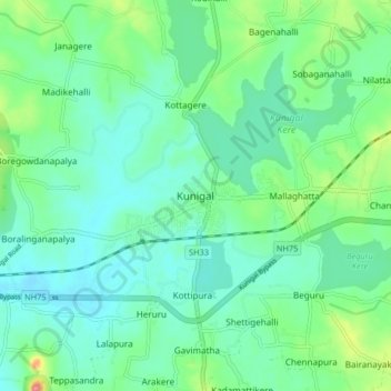
Nombre: Mapa topográfico Kunigal, altitud, relieve.
Altitud media: 775 m
Altitud mínima: 751 m
Altitud máxima: 850 m
Kunigal is located at 13°01′N 77°02′E / 13.02°N 77.03°E / 13.02; 77.03. It has an average elevation of 773 metres (2536 feet). It is situated on the National Highway 48 ( NH-48 ) connecting Bangalore and Mangalore and State Highway 33 connecting Tumakuru and Madduru. Recently opened Hassan-Bangalore railway line transverses through Kunigal.
Otros mapas topográficos
Haga clic en un mapa para ver su topografía, su altitud y su relieve.
Sugganahalli
India > Karnataka > Kunigal taluk
Sugganahalli, Kunigal taluk, Tumakuru District, Karnataka, India
Altitud media: 676 m
Ujjani
India > Karnataka > Kunigal taluk
Ujjani, Kunigal taluk, Tumkur district, Karnataka, 572123, India
Altitud media: 717 m