
Mapa topográfico Dry Creek
Mapa interactivo
Haga clic en el mapa para ver la altitud.
Acerca de este mapa
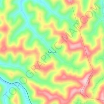
Nombre: Mapa topográfico Dry Creek, altitud, relieve.
Lugar: Dry Creek, Knott County, Kentucky, 41606, United States (37.30482 -82.78794 37.34482 -82.74794)
Altitud media: 425 m
Altitud mínima: 274 m
Altitud máxima: 589 m
Otros mapas topográficos
Haga clic en un mapa para ver su topografía, su altitud y su relieve.
Hindman
United States > Kentucky > Knott County
Hindman, Knott County, Kentucky, United States
Altitud media: 388 m
Knott County
United States > Kentucky > Knott County
Knott County, Kentucky, United States
Altitud media: 412 m