
Haz una donación
Mapa topográfico West Leicester
Haga clic en el mapa para ver la altitud.
Haz una donación
Acerca de este mapa
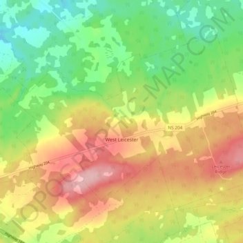
Nombre: Mapa topográfico West Leicester, altitud, relieve.
Altitud media: 114 m
Altitud mínima: 46 m
Altitud máxima: 192 m
Haz una donación
Otros mapas topográficos
Haga clic en un mapa para ver su topografía, su altitud y su relieve.
Chignecto Isthmus
Canada > Nova Scotia > Municipality of the County of Cumberland > Fort Lawrence
Altitud media: 14 m
River Philip Centre
Canada > Nova Scotia > Municipality of the County of Cumberland
Altitud media: 85 m
Mullins Point
Canada > Nova Scotia > Municipality of the County of Cumberland > North Wallace
Altitud media: 2 m
Blue Sea Corner
Canada > Nova Scotia > Municipality of the County of Cumberland > Malagash Point
Altitud media: 11 m
Haz una donación
Westchester Valley
Canada > Nova Scotia > Municipality of the County of Cumberland
Altitud media: 194 m
Glasgow Mountain
Canada > Nova Scotia > Municipality of the County of Cumberland > Diligent River
Altitud media: 143 m
Two Rivers
Canada > Nova Scotia > Municipality of the County of Cumberland > Joggins
Altitud media: 52 m
Canaan Mountains
Canada > Nova Scotia > Municipality of the County of Cumberland > New Canaan
Altitud media: 97 m
Haz una donación
Cameron Beach
Canada > Nova Scotia > Municipality of the County of Cumberland > Port Howe
Altitud media: 2 m
Pugwash Point
Canada > Nova Scotia > Municipality of the County of Cumberland > Pugwash
Altitud media: 4 m
Upper Gulf Shore
Canada > Nova Scotia > Municipality of the County of Cumberland > Gulf Shore
Altitud media: 12 m
Mitchells Beach
Canada > Nova Scotia > Municipality of the County of Cumberland > West Pugwash
Altitud media: 7 m
Haz una donación
Cape Chignecto
Canada > Nova Scotia > Municipality of the County of Cumberland > Cape Chignecto Provincial Park
Altitud media: 20 m
Cape Chignecto
Canada > Nova Scotia > Municipality of the County of Cumberland > Cape Chignecto Provincial Park
Altitud media: 20 m