
Gracias por apoyar a este sitio ❤️
Haz una donación
Haz una donación
Mapa topográfico Zastler-Siedlung
Haga clic en el mapa para ver la altitud.
Gracias por apoyar a este sitio ❤️
Haz una donación
Haz una donación
Acerca de este mapa
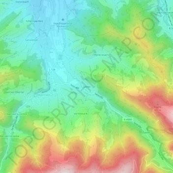
Nombre: Mapa topográfico Zastler-Siedlung, altitud, relieve.
Altitud media: 602 m
Altitud mínima: 396 m
Altitud máxima: 979 m
Gracias por apoyar a este sitio ❤️
Haz una donación
Haz una donación
Otros mapas topográficos
Haga clic en un mapa para ver su topografía, su altitud y su relieve.
St. Wilhelm
Deutschland > Baden-Württemberg > Landkreis Breisgau-Hochschwarzwald > Oberried
Altitud media: 1,052 m