
Haz una donación
Mapa topográfico Beauville
Haga clic en el mapa para ver la altitud.
Haz una donación
Acerca de este mapa
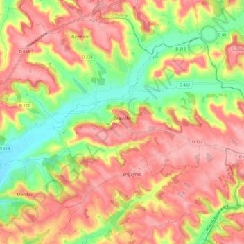
Nombre: Mapa topográfico Beauville, altitud, relieve.
Altitud media: 165 m
Altitud mínima: 77 m
Altitud máxima: 232 m
Haz una donación
Otros mapas topográficos
Haga clic en un mapa para ver su topografía, su altitud y su relieve.
Haz una donación
Haz una donación
Haz una donación
Haz una donación
Haz una donación
Haz una donación
La Planquette
France > Nouvelle-Aquitaine > Lot-et-Garonne > Blanquefort-sur-Briolance
Altitud media: 198 m
Haz una donación
Saint-Vivien
France > Nouvelle-Aquitaine > Lot-et-Garonne > Saint-Eutrope-de-Born
Altitud media: 129 m
Haz una donación
Saint-Marcel
France > Nouvelle-Aquitaine > Lot-et-Garonne > Saint-Sylvestre-sur-Lot
Altitud media: 93 m
Haz una donación
Le Boué
France > Nouvelle-Aquitaine > Lot-et-Garonne > Sainte-Maure-de-Peyriac > Le Boué
Altitud media: 132 m
Haz una donación
Haz una donación
Haz una donación
Haz una donación
Allez et Cazeneuve
France > Nouvelle-Aquitaine > Lot-et-Garonne > Allez-et-Cazeneuve
Altitud media: 106 m
Haz una donación
Samazeuilh
France > Nouvelle-Aquitaine > Lot-et-Garonne > Poussignac > Près de Roujas
Altitud media: 81 m
Haz una donación
Haz una donación
Haz una donación
Château de Bonaguil
France > Nouvelle-Aquitaine > Lot-et-Garonne > Saint-Front-sur-Lémance > Bonaguil
Altitud media: 177 m
Haz una donación
Haz una donación
Côtes du Port de Penne
France > Nouvelle-Aquitaine > Lot-et-Garonne > Port de Penne
Altitud media: 89 m
Camp de Saint-Jean
France > Nouvelle-Aquitaine > Lot-et-Garonne > Saint-Jean-de-Thurac
Altitud media: 78 m
Haz una donación
Haz una donación
Haz una donación
Cumbals
France > Nouvelle-Aquitaine > Lot-et-Garonne > Saint-Étienne-de-Villeréal
Altitud media: 122 m
Haz una donación
Haz una donación
Haz una donación