
Gracias por apoyar a este sitio ❤️
Haz una donación
Haz una donación
Mapa topográfico Roßlau
Haga clic en el mapa para ver la altitud.
Gracias por apoyar a este sitio ❤️
Haz una donación
Haz una donación
Acerca de este mapa
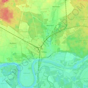
Nombre: Mapa topográfico Roßlau, altitud, relieve.
Altitud media: 71 m
Altitud mínima: 49 m
Altitud máxima: 108 m
Gracias por apoyar a este sitio ❤️
Haz una donación
Haz una donación
Otros mapas topográficos
Haga clic en un mapa para ver su topografía, su altitud y su relieve.
Dessau
Deutschland > Sachsen-Anhalt > Dessau-Roßlau
Im Süden grenzt die Stadt an die waldreiche Mosigkauer Heide, in der die Taube entspringt. Dessau liegt auf einer Höhe von 61 m ü. NN. Die höchste Erhebung ist die ca. 110 m hohe ehemalige Mülldeponie (Scherbelberg) im Südwesten der Stadt. Dessau ist von zahlreichen Schloss- und Parkanlagen umgeben und…
Altitud media: 62 m
Innerstädtischer Bereich Nord
Deutschland > Sachsen-Anhalt > Dessau-Roßlau > Dessau
Altitud media: 61 m