
Mapa topográfico Tagum
Haga clic en el mapa para ver la altitud.
Tagum
One of the significant accomplishments of the officialdom of Tagum during the 1990s was its elevation from a second to the first-class municipality. This opened a gateway to increase its financial resources through the Internal Revenue Allocation (IRA) from the national government and local revenues.
Acerca de este mapa
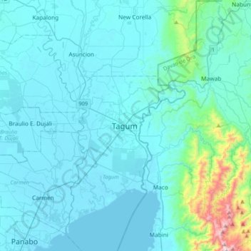
Nombre: Mapa topográfico Tagum, altitud, relieve.
Lugar: Tagum, Davao del Norte, Davao Region, 8100, Philippines (7.28702 125.65118 7.60702 125.97118)
Altitud media: 103 m
Altitud mínima: 0 m
Altitud máxima: 1,143 m