
Mapa topográfico Moab
Mapa interactivo
Haga clic en el mapa para ver la altitud.
Acerca de este mapa
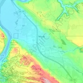
Nombre: Mapa topográfico Moab, altitud, relieve.
Lugar: Moab, Grand County, Utah, 84532, United States (38.53621 -109.57965 38.60318 -109.51532)
Altitud media: 1,357 m
Altitud mínima: 1,200 m
Altitud máxima: 1,746 m
Moab is just south of the Colorado River, at an elevation of 4,025 feet (1,227 m) on the Colorado Plateau. It is 18 miles (29 km) west of the Utah/Colorado state line. Via U.S. Route 191, it is 31 miles (50 km) south of Interstate 70 at Crescent Junction, and it is 54 miles (87 km) north of Monticello. Via Utah State Route 128 it is 46 miles (74 km) southwest of Cisco. The entrance to Arches National Park is 4 miles (6 km) north of Moab on US 191. Hurrah Pass is located on the trail between Moab and Chicken Corners.
Otros mapas topográficos
Haga clic en un mapa para ver su topografía, su altitud y su relieve.
Manns Peak
United States > Utah > Grand County
Manns Peak, Grand County, Utah, United States
Altitud media: 3,427 m
Castle Valley
United States > Utah > Grand County
Castle Valley, Grand County, Utah, United States
Altitud media: 1,610 m
Castleton Tower
United States > Utah > Grand County
Castleton Tower, Grand County, Utah, United States
Altitud media: 1,549 m
Arches National Park
United States > Utah > Grand County
Arches National Park, Grand County, Utah, United States
Altitud media: 1,476 m