
Haz una donación
Mapa topográfico Portal
Haga clic en el mapa para ver la altitud.
Haz una donación
Acerca de este mapa
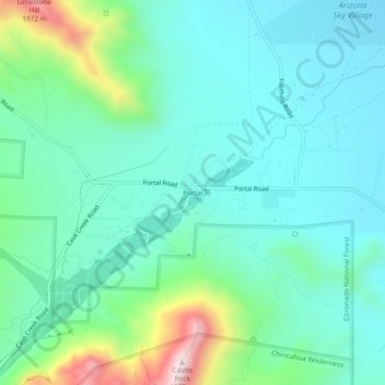
Nombre: Mapa topográfico Portal, altitud, relieve.
Lugar: Portal, Cochise County, Arizona, United States (31.89359 -109.16143 31.93359 -109.12143)
Altitud media: 1,523 m
Altitud mínima: 1,386 m
Altitud máxima: 2,006 m
Haz una donación
Otros mapas topográficos
Haga clic en un mapa para ver su topografía, su altitud y su relieve.
Sierra Vista
United States > Arizona > Cochise County
Sierra Vista occupies a broad high-desert basin in southeastern Arizona, set at about 4,623 feet (1,409 m) above sea level at the foot of the Huachuca Mountains, where the terrain shifts sharply from open valley floors to rugged “sky island” relief. The city lies within the Upper San Pedro Basin, with the…
Altitud media: 1,513 m
Tombstone
United States > Arizona > Cochise County
The Tombstone District located at 31°42′57″N 110°3′53″W / 31.71583°N 110.06472°W / 31.71583; -110.06472 (31.715940, −110.064827) sits atop a mesa (elevation 4,539 feet [1,383 m]) in the San Pedro River valley between the Huachuca Mountains and Whetstone Mountains to the west, and the…
Altitud media: 1,364 m
Haz una donación
Sierra Vista
United States > Arizona > Cochise County
Sierra Vista occupies a broad high-desert basin in southeastern Arizona, set at about 4,623 feet (1,409 m) above sea level at the foot of the Huachuca Mountains, where the terrain shifts sharply from open valley floors to rugged “sky island” relief. The city lies within the Upper San Pedro Basin, with the…
Altitud media: 1,498 m
Haz una donación
Sierra Vista
United States > Arizona > Cochise County
Sierra Vista occupies a broad high-desert basin in southeastern Arizona, set at about 4,623 feet (1,409 m) above sea level at the foot of the Huachuca Mountains, where the terrain shifts sharply from open valley floors to rugged “sky island” relief. The city lies within the Upper San Pedro Basin, with the…
Altitud media: 1,513 m
Haz una donación