
Haz una donación
Mapa topográfico Chilterns National Landscape
Haga clic en el mapa para ver la altitud.
Haz una donación
Chilterns National Landscape
The highest point is 267 m (876 ft.) above sea level at Haddington Hill near Wendover in Buckinghamshire; a stone monument marks the summit. The nearby Ivinghoe Beacon is a more prominent hill, although its altitude is only 249 m (817 ft.). It is the starting point of the Icknield Way Path and the Ridgeway long-distance path, which follow the line of the Chilterns for many miles to the west, where they merge with the Wiltshire downs and southern Cotswolds.
Haz una donación
Acerca de este mapa
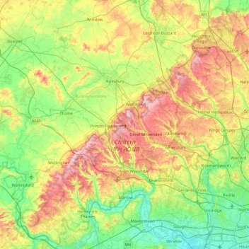
Nombre: Mapa topográfico Chilterns National Landscape, altitud, relieve.
Altitud media: 102 m
Altitud mínima: 14 m
Altitud máxima: 269 m
Haz una donación
Otros mapas topográficos
Haga clic en un mapa para ver su topografía, su altitud y su relieve.
Haz una donación
Haz una donación
Haz una donación
Haz una donación
Haz una donación
Haz una donación
Haz una donación
Haz una donación
Haz una donación
Haz una donación
Haz una donación
Haz una donación
Hotley Bottom
United Kingdom > England > Buckinghamshire > Great Missenden > Prestwood
Altitud media: 182 m
Haz una donación
Haz una donación
Haz una donación
Haz una donación
Haz una donación
Haz una donación
Haz una donación
Haz una donación
Haz una donación
Haz una donación