
Mapa topográfico Wolfeboro
Mapa interactivo
Haga clic en el mapa para ver la altitud.
Acerca de este mapa
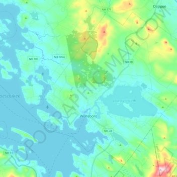
Nombre: Mapa topográfico Wolfeboro, altitud, relieve.
Lugar: Wolfeboro, Carroll County, New Hampshire, United States (43.53895 -71.28488 43.68028 -71.05920)
Altitud media: 213 m
Altitud mínima: 149 m
Altitud máxima: 555 m
According to the United States Census Bureau, the town has a total area of 58.5 square miles (151.4 km2), of which 48.0 square miles (124.2 km2) are land and 10.5 square miles (27.2 km2) are water, comprising 17.95% of the town. Wolfeboro is drained by the Smith River, which is the outlet of Lake Wentworth and an inlet of Lake Winnipesaukee. Via Winnipesaukee, the town is part of the Merrimack River watershed. The highest point in town is Moody Mountain, elevation 1,420 feet (430 m) above sea level, located near the northern boundary.
Otros mapas topográficos
Haga clic en un mapa para ver su topografía, su altitud y su relieve.
Eaton
United States > New Hampshire > Carroll County
Eaton, Carroll County, New Hampshire, 03832, United States
Altitud media: 262 m
Ossipee
United States > New Hampshire > Carroll County
Ossipee, Carroll County, New Hampshire, United States
Altitud media: 217 m
Sandwich
United States > New Hampshire > Carroll County
Sandwich, Carroll County, New Hampshire, 03259, United States
Altitud media: 373 m
Flat Mountain
United States > New Hampshire > Carroll County > Sandwich
Flat Mountain, Sandwich, Carroll County, New Hampshire, United States
Altitud media: 629 m
Moultonborough
United States > New Hampshire > Carroll County
Moultonborough, Carroll County, New Hampshire, United States
Altitud media: 243 m
Albany
United States > New Hampshire > Carroll County > Albany
Albany, Carroll County, New Hampshire, United States
Altitud media: 276 m
Bayle Mountain
United States > New Hampshire > Carroll County > Ossipee
Bayle Mountain, Ossipee, Carroll County, New Hampshire, United States
Altitud media: 405 m
Bartlett
United States > New Hampshire > Carroll County
Bartlett, Carroll County, New Hampshire, United States
Altitud media: 493 m
Whitton Pond
United States > New Hampshire > Carroll County > Albany
Whitton Pond, Albany, Carroll County, New Hampshire, United States
Altitud media: 273 m
Albany
United States > New Hampshire > Carroll County > Albany
Albany, Carroll County, New Hampshire, 03818, United States
Altitud media: 409 m
Tamworth
United States > New Hampshire > Carroll County > Tamworth
Tamworth, Carroll County, New Hampshire, United States
Altitud media: 263 m
Conway
United States > New Hampshire > Carroll County
Conway, Carroll County, New Hampshire, United States
Altitud media: 256 m
Freedom
United States > New Hampshire > Carroll County
Freedom, Carroll County, New Hampshire, 03836, United States
Altitud media: 224 m