
Mapa topográfico Ankeny
Mapa interactivo
Haga clic en el mapa para ver la altitud.
Acerca de este mapa
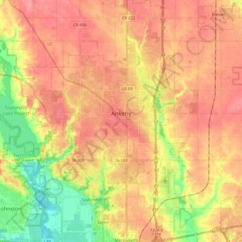
Nombre: Mapa topográfico Ankeny, altitud, relieve.
Lugar: Ankeny, Polk County, Iowa, United States (41.65213 -93.67277 41.79132 -93.54144)
Altitud media: 283 m
Altitud mínima: 237 m
Altitud máxima: 310 m
Like most of Polk County, Ankeny exists at the bottom area of the Des Moines Lobe, a topographical landscape area, in an area known as the Bemis Advance. The Lobe was formed during the Wisconsin glaciation leaving significant deposits resulting in an area with low relief.
Otros mapas topográficos
Haga clic en un mapa para ver su topografía, su altitud y su relieve.
Des Moines
United States > Iowa > Polk County
Des Moines, Polk County, Iowa, United States
Altitud media: 264 m
Clive
United States > Iowa > Polk County
Clive, Polk County, Iowa, 50325, United States
Altitud media: 287 m
Polk City
United States > Iowa > Polk County > Polk City > Polk City
Polk City, Polk County, Iowa, 50226, United States
Altitud media: 279 m
West Des Moines
United States > Iowa > Polk County
West Des Moines, Polk County, Iowa, United States
Altitud media: 280 m
Des Moines
United States > Iowa > Polk County > Des Moines
Des Moines, Polk County, Iowa, 50319, United States
Altitud media: 271 m