
Haz una donación
Mapa topográfico Tynemouth Creek
Haga clic en el mapa para ver la altitud.
Haz una donación
Acerca de este mapa
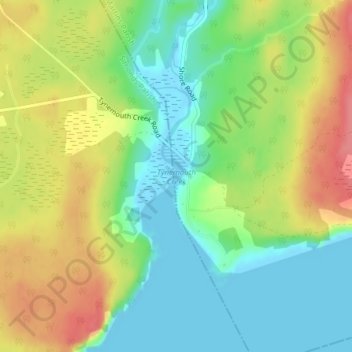
Nombre: Mapa topográfico Tynemouth Creek, altitud, relieve.
Altitud media: 32 m
Altitud mínima: -3 m
Altitud máxima: 75 m
Haz una donación
Otros mapas topográficos
Haga clic en un mapa para ver su topografía, su altitud y su relieve.
City of Saint John
Canada > New Brunswick > Saint John County
The topography surrounding Saint John is hilly; a result of the influence of two coastal mountain ranges which run along the Bay of Fundy – the St. Croix Highlands and the Caledonia Highlands. The soil throughout the region is extremely rocky with frequent granite outcrops. The coastal plain hosts numerous…
Altitud media: 37 m
Bains Corner
Canada > New Brunswick > Saint John County > Village of Fundy-St. Martins
Altitud media: 88 m
Haz una donación
City of Saint John
Canada > New Brunswick > Saint John County
The topography surrounding Saint John is hilly; a result of the influence of two coastal mountain ranges which run along the Bay of Fundy – the St. Croix Highlands and the Caledonia Highlands. The soil throughout the region is extremely rocky with frequent granite outcrops. The coastal plain hosts numerous…
Altitud media: 36 m
City of Saint John
Canada > New Brunswick > Saint John County
The topography surrounding Saint John is hilly; a result of the influence of two coastal mountain ranges which run along the Bay of Fundy – the St. Croix Highlands and the Caledonia Highlands. The soil throughout the region is extremely rocky with frequent granite outcrops. The coastal plain hosts numerous…
Altitud media: 37 m
Haz una donación
Saint John
Canada > New Brunswick > Saint John County
The topography surrounding Saint John is hilly; a result of the influence of two coastal mountain ranges which run along the Bay of Fundy – the St. Croix Highlands and the Caledonia Highlands. The soil throughout the region is extremely rocky with frequent granite outcrops. The coastal plain hosts numerous…
Altitud media: 37 m