
Mapa topográfico Clayton
Mapa interactivo
Haga clic en el mapa para ver la altitud.
Acerca de este mapa
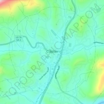
Nombre: Mapa topográfico Clayton, altitud, relieve.
Lugar: Clayton, Rabun County, Georgia, 30525, United States (34.86293 -83.42541 34.89285 -83.38348)
Altitud media: 621 m
Altitud mínima: 534 m
Altitud máxima: 918 m
According to the United States Census Bureau, the city has a total area of 3.1 square miles (8.0 km2), all of it land. The elevation of Clayton's downtown area is 1,925 feet (587 m). A number of hilltops within the city limits exceed 2,200 feet.
Otros mapas topográficos
Haga clic en un mapa para ver su topografía, su altitud y su relieve.
Mountain City
United States > Georgia > Rabun County
Mountain City, Rabun County, Georgia, 30562, United States
Altitud media: 747 m
Chestnut Mountain
United States > Georgia > Rabun County
Chestnut Mountain, Rabun County, Georgia, 30537, United States
Altitud media: 834 m
Sky Valley
United States > Georgia > Rabun County
Sky Valley, Rabun County, Georgia, 30537, United States
Altitud media: 973 m
Elisha Mountain
United States > Georgia > Rabun County
Elisha Mountain, Rabun County, Georgia, 30525, United States
Altitud media: 828 m
Lake Burton
United States > Georgia > Rabun County
Lake Burton, Rabun County, Georgia, United States
Altitud media: 662 m
Blalock
United States > Georgia > Rabun County
Blalock, Rabun County, Georgia, United States
Altitud media: 682 m
Black Rock Mountain State Park
United States > Georgia > Rabun County > Mountain City
Black Rock Mountain State Park, Mountain City, Rabun County, Georgia, United States
Altitud media: 833 m
Tallulah Gorge State Park
United States > Georgia > Rabun County > Tallulah Falls
Tallulah Gorge State Park, Tallulah Falls, Rabun County, Georgia, United States
Altitud media: 435 m
Tallulah Gorge
United States > Georgia > Rabun County > Tallulah Falls
Tallulah Gorge, Tallulah Falls, Rabun County, Georgia, United States
Altitud media: 465 m
Lakemont
United States > Georgia > Rabun County
Lakemont, Rabun County, Georgia, 30581, United States
Altitud media: 547 m
Dillard
United States > Georgia > Rabun County
Dillard, Rabun County, Georgia, United States
Altitud media: 691 m
Rabun Gap Nacoochee School Lake
United States > Georgia > Rabun County
Rabun Gap Nacoochee School Lake, Rabun County, Georgia, United States
Altitud media: 671 m
Ben Mountain
United States > Georgia > Rabun County
Ben Mountain, Rabun County, Georgia, 30537, United States
Altitud media: 866 m
Rabun Gap Nacoochee School Lake Dam
United States > Georgia > Rabun County
Rabun Gap Nacoochee School Lake Dam, Rabun County, Georgia, 30568, United States
Altitud media: 671 m
Lake Seed
United States > Georgia > Rabun County
Lake Seed, Rabun County, Georgia, United States
Altitud media: 653 m