
Gracias por apoyar a este sitio ❤️
Haz una donación
Haz una donación
Mapa topográfico Hometown
Haga clic en el mapa para ver la altitud.
Gracias por apoyar a este sitio ❤️
Haz una donación
Haz una donación
Hometown
According to the United States Census Bureau, the CDP has a total area of 2.0 square miles (5.2 km2), all land. Hometown is located 2 miles (3.2 km) north of Tamaqua and 10 miles (16 km) south of Hazleton at the intersections of Route 54 and 309. Hometown's elevation is 1,129 feet (344 m) above sea level. It uses the Tamaqua zip code of 18252.
Gracias por apoyar a este sitio ❤️
Haz una donación
Haz una donación
Acerca de este mapa
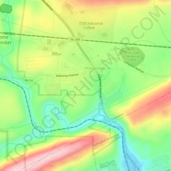
Nombre: Mapa topográfico Hometown, altitud, relieve.
Altitud media: 352 m
Altitud mínima: 249 m
Altitud máxima: 481 m
Gracias por apoyar a este sitio ❤️
Haz una donación
Haz una donación