
Mapa topográfico Pulilan
Mapa interactivo
Haga clic en el mapa para ver la altitud.
Acerca de este mapa
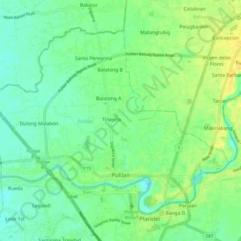
Nombre: Mapa topográfico Pulilan, altitud, relieve.
Lugar: Pulilan, Bulacan, Central Luzon, 3005, Philippines (14.88783 120.79772 14.95701 120.89039)
Altitud media: 10 m
Altitud mínima: 0 m
Altitud máxima: 22 m
The municipality is generally of flat topography. Eleven (11) of its barangays are bounded by the Angat River. The rest are flat irrigated rice lands. Soil types vary from sandy loam to clay loam which makes the municipality suitable to a wide range of agricultural products.
Otros mapas topográficos
Haga clic en un mapa para ver su topografía, su altitud y su relieve.
Pulilan
Philippines > Bulacan > Pulilan
Pulilan, Bulacan, Central Luzon, 3005, Philippines
Altitud media: 9 m