
Mapa topográfico Westwood
Haga clic en el mapa para ver la altitud.
Acerca de este mapa
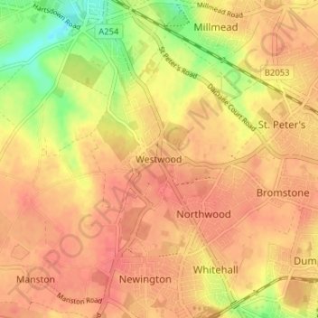
Nombre: Mapa topográfico Westwood, altitud, relieve.
Altitud media: 40 m
Altitud mínima: 4 m
Altitud máxima: 56 m
Otros mapas topográficos
Haga clic en un mapa para ver su topografía, su altitud y su relieve.
Stour
United Kingdom > England > Kent > Thanet District
The source, of what is known at that point as the Great Stour, is near the village of Lenham, within a short distance of the River Len, a tributary of the Medway. The source is at a high elevation close to the North Downs escarpment. At first the river flows south east in a narrow valley parallel to the…
Altitud media: 7 m