
Gracias por apoyar a este sitio ❤️
Haz una donación
Haz una donación
Mapa topográfico Netherne-on-the-Hill
Haga clic en el mapa para ver la altitud.
Gracias por apoyar a este sitio ❤️
Haz una donación
Haz una donación
Acerca de este mapa
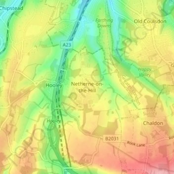
Nombre: Mapa topográfico Netherne-on-the-Hill, altitud, relieve.
Altitud media: 153 m
Altitud mínima: 90 m
Altitud máxima: 218 m
Gracias por apoyar a este sitio ❤️
Haz una donación
Haz una donación
Otros mapas topográficos
Haga clic en un mapa para ver su topografía, su altitud y su relieve.
Banstead Wood
United Kingdom > England > Surrey > Reigate and Banstead > Chipstead
Altitud media: 145 m
Gracias por apoyar a este sitio ❤️
Haz una donación
Haz una donación
Horley
United Kingdom > England > Surrey > Reigate and Banstead
Horley is at an altitude of around 54 m (177 ft) above mean sea level.
Altitud media: 58 m
Lower Earlswood Lake
United Kingdom > England > Surrey > Reigate and Banstead > Redhill
Altitud media: 75 m