
Mapa topográfico Town of Manheim
Mapa interactivo
Haga clic en el mapa para ver la altitud.
Acerca de este mapa
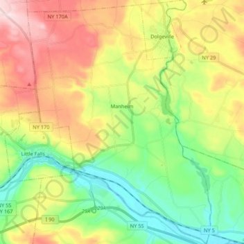
Nombre: Mapa topográfico Town of Manheim, altitud, relieve.
Altitud media: 246 m
Altitud mínima: 89 m
Altitud máxima: 474 m
Otros mapas topográficos
Haga clic en un mapa para ver su topografía, su altitud y su relieve.
Stratford
United States > New York > Herkimer County
Stratford, Town of Salisbury, Herkimer County, New York, 13470, United States
Altitud media: 359 m
City of Little Falls
United States > New York > Herkimer County
City of Little Falls, Town of Little Falls, Herkimer County, New York, 13365, United States
Altitud media: 223 m
Old Forge
United States > New York > Herkimer County
Old Forge, Town of Webb, Herkimer County, New York, United States
Altitud media: 543 m
Harbor
United States > New York > Herkimer County > Harbor
Harbor, Town of Frankfort, Herkimer County, New York, 13504, United States
Altitud media: 156 m
Bull Hill
United States > New York > Herkimer County > Bull Hill
Bull Hill, Town of Ohio, Herkimer County, New York, United States
Altitud media: 421 m
Manheim Center
United States > New York > Herkimer County > Manheim Center
Manheim Center, Town of Manheim, Herkimer County, New York, United States
Altitud media: 196 m
Kast Bridge
United States > New York > Herkimer County > Kast Bridge
Kast Bridge, Town of Herkimer, Herkimer County, New York, 13350, United States
Altitud media: 218 m
Eagle Bay
United States > New York > Herkimer County > Eagle Bay
Eagle Bay, Town of Webb, Herkimer County, New York, 13360, United States
Altitud media: 551 m