
Haz una donación
Mapa topográfico Addenbroke Island Lighthouse
Haga clic en el mapa para ver la altitud.
Haz una donación
Acerca de este mapa
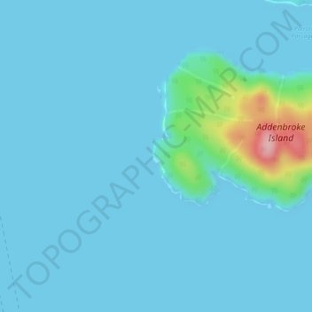
Nombre: Mapa topográfico Addenbroke Island Lighthouse, altitud, relieve.
Altitud media: 14 m
Altitud mínima: 0 m
Altitud máxima: 155 m
Haz una donación
Otros mapas topográficos
Haga clic en un mapa para ver su topografía, su altitud y su relieve.
Triquet Island
Canada > British Columbia > Central Coast Regional District > Area A (Ocean Falls/Outer Coast)
Altitud media: 3 m
Owikeno Lake
Canada > British Columbia > Central Coast Regional District > Area A (Ocean Falls/Outer Coast)
Altitud media: 258 m
Calvert Island
Canada > British Columbia > Central Coast Regional District > Area A (Ocean Falls/Outer Coast)
Altitud media: 68 m
Convoy Passage
Canada > British Columbia > Central Coast Regional District > Area A (Ocean Falls/Outer Coast)
Altitud media: 28 m
Haz una donación
Calvert Island
Canada > British Columbia > Central Coast Regional District > Area A (Ocean Falls/Outer Coast)
Altitud media: 68 m
Hurricane Island
Canada > British Columbia > Central Coast Regional District > Area A (Ocean Falls/Outer Coast)
Altitud media: 14 m
Hunter Island
Canada > British Columbia > Central Coast Regional District > Area A (Ocean Falls/Outer Coast)
Altitud media: 36 m