
Mapa topográfico Gatton
Haga clic en el mapa para ver la altitud.
Gatton
Gatton's elevations range from 215m AOD, the highest elevation, along Fort Lane, a cul-de-sac off the intersection of Reigate Hill (M25 Junction 8) which leads to four homes over the boundary in Reigate, a radio transmitter station, and a water tower. On the A217 is the Bridge House Hotel, whose name refers to a footbridge carrying the North Downs Way across the A217 85m to the east.
Acerca de este mapa
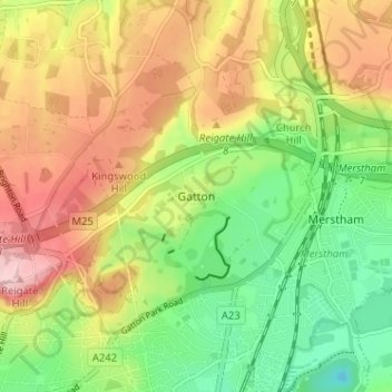
Nombre: Mapa topográfico Gatton, altitud, relieve.
Altitud media: 134 m
Altitud mínima: 46 m
Altitud máxima: 236 m
Otros mapas topográficos
Haga clic en un mapa para ver su topografía, su altitud y su relieve.
Lower Earlswood Lake
United Kingdom > England > Surrey > Reigate and Banstead > Redhill
Altitud media: 75 m
Banstead Wood
United Kingdom > England > Surrey > Reigate and Banstead > Chipstead
Altitud media: 145 m
Horley
United Kingdom > England > Surrey > Reigate and Banstead
Horley is at an altitude of around 54 m (177 ft) above mean sea level.
Altitud media: 58 m