
Mapa topográfico Tochal
Mapa interactivo
Haga clic en el mapa para ver la altitud.
Acerca de este mapa
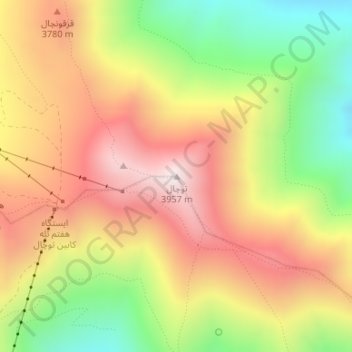
Nombre: Mapa topográfico Tochal, altitud, relieve.
Lugar: Tochal, رودبار قصران, Shemiranat County, Tehran Province, Iran (35.88430 51.41982 35.88440 51.41992)
Altitud media: 3,562 m
Altitud mínima: 3,122 m
Altitud máxima: 3,958 m
Tochal (Persian: توچال Točāl), is a mountain and ski resort located on the Alborz mountain range, adjacent to the metropolitan area of Tehran in northern Iran. It includes a 12-kilometre-long (7.5 mi) ridge. Its highest peak, also called Tochal, is at an elevation of 3,964 metres (13,005 ft).
Otros mapas topográficos
Haga clic en un mapa para ver su topografía, su altitud y su relieve.
Rey City
Iran > Tehran Province > Rey City
Rey, Rey City, بخش مرکزی شهرستان ری, Rey County, Tehran Province, 18499, Iran
Altitud media: 1,075 m
Rey County
Rey City, بخش مرکزی شهرستان ری, Rey County, Tehran Province, Iran
Altitud media: 1,070 m