
Haz una donación
Mapa topográfico West Willoughby
Haga clic en el mapa para ver la altitud.
Haz una donación
Acerca de este mapa
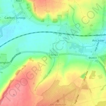
Nombre: Mapa topográfico West Willoughby, altitud, relieve.
Altitud media: 74 m
Altitud mínima: 38 m
Altitud máxima: 125 m
Haz una donación
Otros mapas topográficos
Haga clic en un mapa para ver su topografía, su altitud y su relieve.
Carlton Scroop
United Kingdom > England > Lincolnshire > South Kesteven > Carlton Scroop
Altitud media: 64 m
Haz una donación
Haz una donación
Haz una donación
Witham on the Hill
United Kingdom > England > Lincolnshire > South Kesteven > Witham on the Hill
Altitud media: 45 m
Uffington Park
United Kingdom > England > Lincolnshire > South Kesteven > Uffington
Altitud media: 30 m
Haz una donación
Little Bytham
United Kingdom > England > Lincolnshire > South Kesteven > Little Bytham
Altitud media: 62 m
Deeping St. James
United Kingdom > England > Lincolnshire > South Kesteven > Frognall
Altitud media: 5 m
Haz una donación
Woolsthorpe By Belvoir
United Kingdom > England > Lincolnshire > South Kesteven > Woolsthorpe-by-Belvoir
Altitud media: 74 m
Haz una donación
Witham on the Hill
United Kingdom > England > Lincolnshire > South Kesteven > Witham on the Hill
Altitud media: 45 m