
Gracias por apoyar a este sitio ❤️
Haz una donación
Haz una donación
Mapa topográfico Rāmnagar
Haga clic en el mapa para ver la altitud.
Gracias por apoyar a este sitio ❤️
Haz una donación
Haz una donación
Rāmnagar
It has an average elevation of roughly 345 metres (1,132 feet). Ramnagar is located at the foothills of the Himalayas on the bank of river Kosi. The town is visited by many tourists due to its geographical location near Corbett National Park. Its proximity to Nainital which is a famous hill station of Northern India makes it even more popular. There is a Barrage on Kosi River in Ramnagar where many migratory birds such as Ruddy Shelduck arrive in winter.
Gracias por apoyar a este sitio ❤️
Haz una donación
Haz una donación
Acerca de este mapa
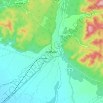
Nombre: Mapa topográfico Rāmnagar, altitud, relieve.
Lugar: Rāmnagar, Ramnagar, Nainital, Uttarakhand, 244715, India (29.35484 79.08693 29.43484 79.16693)
Altitud media: 391 m
Altitud mínima: 303 m
Altitud máxima: 640 m
Gracias por apoyar a este sitio ❤️
Haz una donación
Haz una donación