
Haz una donación
Mapa topográfico Sogod
Haga clic en el mapa para ver la altitud.
Haz una donación
Sogod
On May 18, 1700, the colonial government of the Philippines established Sogod as a regular visita [satellite barrio with chapel]. With this elevation, a concrete church finally stood in the settlement in the year 1718. The construction was made possible through the mandate of the Most Reverend Sebastian Foronda, OSA, bishopric of Cebu. Eventually, more subdistricts in the vicinity of Sogod came into existence such as the barrio of Maak, which was established on February 3, 1730 while the barrio of Buntuk was erected on April 10, 1750.
Haz una donación
Acerca de este mapa
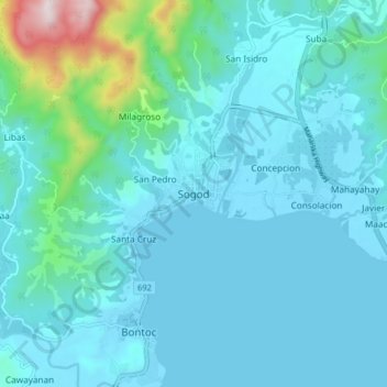
Nombre: Mapa topográfico Sogod, altitud, relieve.
Lugar: Sogod, Southern Leyte, Eastern Visayas, 6606, Philippines (10.34459 124.94080 10.42459 125.02080)
Altitud media: 94 m
Altitud mínima: 0 m
Altitud máxima: 787 m
Haz una donación
Otros mapas topográficos
Haga clic en un mapa para ver su topografía, su altitud y su relieve.