
Gracias por apoyar a este sitio ❤️
Haz una donación
Haz una donación
Mapa topográfico Chakan
Haga clic en el mapa para ver la altitud.
Gracias por apoyar a este sitio ❤️
Haz una donación
Haz una donación
Chakan
Shiroli Chandus village, located 6 km north of Chakan, had been identified as the probable site for the proposed Pune International Airport, but due to the protests by the villagers & uneven topography, the site has been shifted to Purandar.
Gracias por apoyar a este sitio ❤️
Haz una donación
Haz una donación
Acerca de este mapa
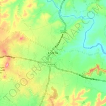
Nombre: Mapa topográfico Chakan, altitud, relieve.
Lugar: Chakan, Khed, Pune District, Maharashtra, 410500, India (18.72231 73.82254 18.80231 73.90254)
Altitud media: 624 m
Altitud mínima: 568 m
Altitud máxima: 712 m
Gracias por apoyar a este sitio ❤️
Haz una donación
Haz una donación
Otros mapas topográficos
Haga clic en un mapa para ver su topografía, su altitud y su relieve.