
Mapa topográfico Byram cum Sutton
Mapa interactivo
Haga clic en el mapa para ver la altitud.
Acerca de este mapa
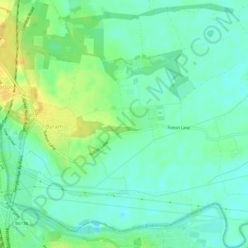
Nombre: Mapa topográfico Byram cum Sutton, altitud, relieve.
Altitud media: 13 m
Altitud mínima: 3 m
Altitud máxima: 29 m
Otros mapas topográficos
Haga clic en un mapa para ver su topografía, su altitud y su relieve.
Saxton
United Kingdom > England > Selby > Saxton
Saxton, Selby, North Yorkshire, Yorkshire and the Humber, England, LS24 9PZ, United Kingdom
Altitud media: 32 m
Brotherton
United Kingdom > England > Selby > Brotherton
Brotherton, Selby, North Yorkshire, Yorkshire and the Humber, England, United Kingdom
Altitud media: 16 m
Carlton
United Kingdom > England > Selby > Carlton
Carlton, Selby, North Yorkshire, Yorkshire and the Humber, England, DN14 9PB, United Kingdom
Altitud media: 5 m
Hemingbrough
United Kingdom > England > Selby
Hemingbrough, Selby, North Yorkshire, Yorkshire and the Humber, England, United Kingdom
Altitud media: 5 m
Carlton
United Kingdom > England > Selby
Carlton, Selby, North Yorkshire, Yorkshire and the Humber, England, United Kingdom
Altitud media: 6 m
Beal
United Kingdom > England > Selby
Beal, Selby, North Yorkshire, Yorkshire and the Humber, England, United Kingdom
Altitud media: 10 m
Brayton
United Kingdom > England > Selby
Brayton, Selby, North Yorkshire, Yorkshire and the Humber, England, United Kingdom
Altitud media: 8 m
Camblesforth
United Kingdom > England > Selby
Camblesforth, Selby, North Yorkshire, Yorkshire and the Humber, England, United Kingdom
Altitud media: 6 m
Kellington
United Kingdom > England > Selby
Kellington, Selby, North Yorkshire, Yorkshire and the Humber, England, United Kingdom
Altitud media: 11 m