
Gracias por apoyar a este sitio ❤️
Haz una donación
Haz una donación
Mapa topográfico Naraingarh
Haga clic en el mapa para ver la altitud.
Gracias por apoyar a este sitio ❤️
Haz una donación
Haz una donación
Naraingarh
Naraingarh is located near the foothills of the Sivalik range of the Himalayas in northwest India. It covers an area of approximately 481 km2. It shares its borders with the states of Himachal Pradesh. The exact cartographic co-ordinates of Narayangarh are 30°28′N 77°08′E / 30.47°N 77.13°E / 30.47; 77.13.It has an average elevation of 325 metres (1065 ft).
Gracias por apoyar a este sitio ❤️
Haz una donación
Haz una donación
Acerca de este mapa
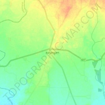
Nombre: Mapa topográfico Naraingarh, altitud, relieve.
Lugar: Naraingarh, Ambala, Haryana, 134203, India (30.43239 77.08427 30.51239 77.16427)
Altitud media: 321 m
Altitud mínima: 305 m
Altitud máxima: 342 m
Gracias por apoyar a este sitio ❤️
Haz una donación
Haz una donación