
Haz una donación
Mapa topográfico Kotagiri
Haga clic en el mapa para ver la altitud.
Haz una donación
Kotagiri
Kotagiri is a Hill town and a taluk in The Nilgiris District in the Indian state of Tamil Nadu. The name 'Kota-giri' itself means 'mountain of the Kotas'. The town has developed around numerous knolls and valleys. It is one of the largest hill station in the Nilgiri Mountains. Located at an average elevation of 1,950 m (6,400 ft), Kotagiri is quietly tucked away in the Nilgiris and used to be one of the summer resort of Madras Presidency. The town was discovered in the year 1819 by John Sullivan when he came to a village called Dhimbatty to the North of Kotagiri. Situated at an elevation of about 6,400 feet, Kotagiri enjoys the third coldest climate next to Ooty and Kodaikanal in South India.
Haz una donación
Acerca de este mapa
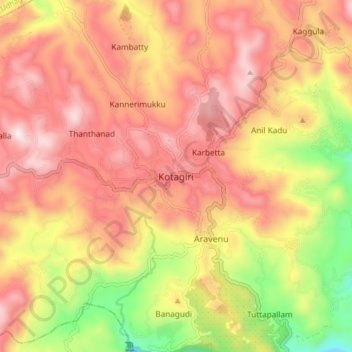
Nombre: Mapa topográfico Kotagiri, altitud, relieve.
Lugar: Kotagiri, Nilgiris, Tamil Nadu, 643217, India (11.38304 76.82582 11.46304 76.90582)
Altitud media: 1,781 m
Altitud mínima: 1,290 m
Altitud máxima: 2,125 m
Haz una donación
Otros mapas topográficos
Haga clic en un mapa para ver su topografía, su altitud y su relieve.