
Mapa topográfico Toravalli
Haga clic en el mapa para ver la altitud.
Acerca de este mapa
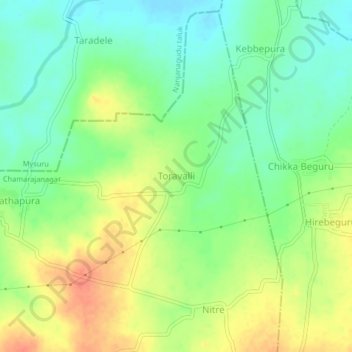
Nombre: Mapa topográfico Toravalli, altitud, relieve.
Lugar: Toravalli, Gundlupet taluk, Chamarajanagar, Karnataka, India (11.96439 76.71117 12.00439 76.75117)
Altitud media: 722 m
Altitud mínima: 700 m
Altitud máxima: 750 m
Otros mapas topográficos
Haga clic en un mapa para ver su topografía, su altitud y su relieve.
Bandipur National Park
India > Karnataka > Gundlupet taluk
Bandipur National Park is located between 75° 12’ 17" E to 76° 51’ 32" E and 11° 35’ 34" N to 11° 57’ 02" N where the Deccan Plateau meets the Western Ghats, and the altitude of the park ranges from 680 m (2,230 ft) to 1,454 m (4,770 ft). As a result, the park has a variety of biomes including dry…
Altitud media: 860 m