
Haz una donación
Mapa topográfico Torreys Peak
Haga clic en el mapa para ver la altitud.
Haz una donación
Torreys Peak
The third trail starts at Loveland Pass about 4.5 miles (7.2 km) to the northwest. To reach Loveland Pass, follow I-70 west from Denver 55 miles (89 km) to where US Route 6 breaks off and heads south. Follow the meandering Route 6 approximately seven miles to the trailhead at Loveland Pass, at an elevation of 11,990 feet (3,650 m). The steepest part of the trail actually begins right away with a half mile climb of 1,000 feet (300 m). The trail follows the Continental Divide gently taking the climber down into three saddles and up two more peaks, including Grizzly Peak at 13,427 feet (4,093 m) and Mount Sniktau at 13,234 feet (4,034 m). The final saddle rests at approximately 12,600 ft. From this saddle, it is a mile-long ascent of 1,800 feet (550 m) to the final summit.
Haz una donación
Acerca de este mapa
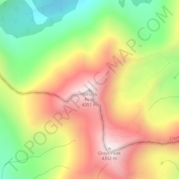
Nombre: Mapa topográfico Torreys Peak, altitud, relieve.
Lugar: Torreys Peak, Clear Creek County, Colorado, United States (39.64271 -105.82145 39.64281 -105.82135)
Altitud media: 3,855 m
Altitud mínima: 3,369 m
Altitud máxima: 4,341 m
Haz una donación
Otros mapas topográficos
Haga clic en un mapa para ver su topografía, su altitud y su relieve.