
Haz una donación
Mapa topográfico Champhai
Haga clic en el mapa para ver la altitud.
Haz una donación
Acerca de este mapa
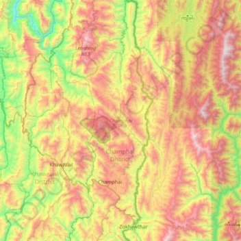
Nombre: Mapa topográfico Champhai, altitud, relieve.
Lugar: Champhai, Champhai district, Mizoram, 796321, India (23.32964 93.25127 23.93434 93.43737)
Altitud media: 1,125 m
Altitud mínima: 197 m
Altitud máxima: 2,349 m
Haz una donación
Otros mapas topográficos
Haga clic en un mapa para ver su topografía, su altitud y su relieve.
Aizawl
Aizawl (English: /ˈaɪzɔːl/ EYE-zawl; Mizo: [ˈaɪ̯.ˈzɔːl] ), formerly known as Aijal, is the capital city and the most populous city of Mizoram, India. It is also the third largest city in northeast India. It is situated atop a series of ridges, with an average elevation of around 1,132 metres (3,714…
Altitud media: 562 m
Haz una donación
Haz una donación
Aizawl
Aizawl (English: /aɪˈzɔːl/; Mizo: [ˈaɪ̯.ˈzɔːl] ), formerly known as Aijal, is the capital city and the most populous city of Mizoram, India. It is also the third largest city in northeast India, after Guwahati and Agartala. It is situated atop a series of ridges, with an average elevation of around…
Altitud media: 562 m
Aizawl
Aizawl has a mild, sub-tropical climate due to its location and elevation. Under the Köppen climate classification, Aizawl features a humid subtropical climate (Cwa). In summer, temperatures are moderately warm, averaging around 20–30 °C (68–86 °F). In winter, daytime temperatures are cooler in…
Altitud media: 556 m
Haz una donación