
Haz una donación
Mapa topográfico Chapman's Dell
Haga clic en el mapa para ver la altitud.
Haz una donación
Acerca de este mapa
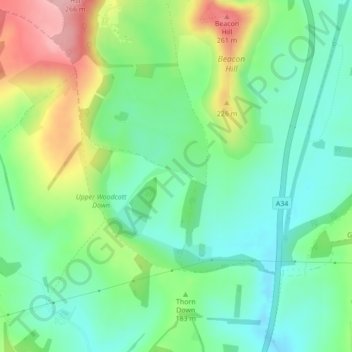
Nombre: Mapa topográfico Chapman's Dell, altitud, relieve.
Altitud media: 173 m
Altitud mínima: 121 m
Altitud máxima: 274 m
Haz una donación
Otros mapas topográficos
Haga clic en un mapa para ver su topografía, su altitud y su relieve.
Basingstoke
United Kingdom > England > Hampshire > Basingstoke and Deane
Situated in a valley through the Hampshire Downs at an average elevation of 88 metres (289 ft) Basingstoke is a major interchange between Reading, Newbury, Andover, Winchester, and Alton, and lies on the natural trade route between the southwest of England and London. The area had been something of an…
Altitud media: 110 m
Morgaston Wood
United Kingdom > England > Hampshire > Basingstoke and Deane > Sherborne St John
Altitud media: 76 m
Haz una donación
Mortimer West End
United Kingdom > England > Hampshire > Basingstoke and Deane > Mortimer West End
Altitud media: 90 m
Haz una donación
Wootton St. Lawrence
United Kingdom > England > Hampshire > Basingstoke and Deane
Altitud media: 115 m
Haz una donación
Sherborne St. John
United Kingdom > England > Hampshire > Basingstoke and Deane > Sherborne St John
Altitud media: 79 m
Bramley Corner
United Kingdom > England > Hampshire > Basingstoke and Deane > Bramley
Altitud media: 69 m
Haz una donación
Highclere
United Kingdom > England > Hampshire > Basingstoke and Deane > Highclere
Altitud media: 154 m
Haz una donación
Monk Sherborne
United Kingdom > England > Hampshire > Basingstoke and Deane > Monk Sherborne
Altitud media: 107 m
Kingsclere
United Kingdom > England > Hampshire > Basingstoke and Deane > Kingsclere
Altitud media: 139 m
Haz una donación
Chineham
United Kingdom > England > Hampshire > Basingstoke and Deane > Basingstoke
Altitud media: 78 m
River Lyde
United Kingdom > England > Hampshire > Basingstoke and Deane > Up Nately
Altitud media: 78 m
Haz una donación
Baughurst
United Kingdom > England > Hampshire > Basingstoke and Deane > Wolverton Townsend
Altitud media: 106 m
St. Mary Bourne
United Kingdom > England > Hampshire > Basingstoke and Deane > Stoke
Altitud media: 125 m
Haz una donación
East Woodhay
United Kingdom > England > Hampshire > Basingstoke and Deane > East End
Altitud media: 171 m
Haz una donación
Highclere
United Kingdom > England > Hampshire > Basingstoke and Deane > Highclere
Altitud media: 154 m
Haz una donación
Chineham
United Kingdom > England > Hampshire > Basingstoke and Deane > Basingstoke
Altitud media: 78 m
Haz una donación
Highclere
United Kingdom > England > Hampshire > Basingstoke and Deane > Highclere
Altitud media: 154 m