
Haz una donación
Mapa topográfico Dinorwic
Haga clic en el mapa para ver la altitud.
Haz una donación
Acerca de este mapa
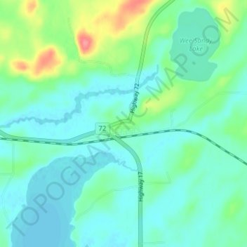
Nombre: Mapa topográfico Dinorwic, altitud, relieve.
Altitud media: 383 m
Altitud mínima: 367 m
Altitud máxima: 439 m
Haz una donación
Otros mapas topográficos
Haga clic en un mapa para ver su topografía, su altitud y su relieve.
lac Seul
Canada > Ontario > Kenora District > Unorganized Kenora District
Lac Seul is a large, crescent shaped reservoir in Kenora District, northwestern Ontario, Canada. It is approximately 241 km (150 mi) long. It has a maximum (regulated) depth of 47.2 m, with a surface elevation of 357 m above sea level. Its level is raised in the summer and then drawn down in the winter months…
Altitud media: 374 m
Haz una donación
Cardinal (Lac) Lake
Canada > Ontario > Kenora District > Unorganized Kenora District
Altitud media: 392 m
Haz una donación
Haz una donación
Haz una donación
Confederation Lake
Canada > Ontario > Kenora District > Unorganized Kenora District
Altitud media: 414 m
Haz una donación
Haz una donación
Haz una donación
Haz una donación
Haz una donación
Haz una donación
Haz una donación
Haz una donación
Haz una donación
Little Boulder Lake
Canada > Ontario > Kenora District > Unorganized Kenora District
Altitud media: 359 m
Haz una donación