
Mapa topográfico Isle Au Haut
Mapa interactivo
Haga clic en el mapa para ver la altitud.
Acerca de este mapa
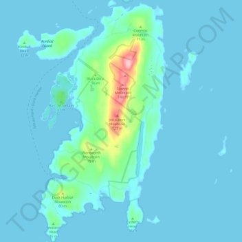
Nombre: Mapa topográfico Isle Au Haut, altitud, relieve.
Altitud media: 14 m
Altitud mínima: -1 m
Altitud máxima: 160 m
Mount Champlain, elevation 540 feet (160 m), is the highest point on the island, located on a north-south ridge occupying the island's center. Rocky Mountain, elevation 511 feet (156 m), and Sawyer Mountain, at 486 feet (148 m), are neighboring summits along the ridge to the south.[8] The terrain consists of low hills covered by temperate coniferous forests; the coastline is mainly granite boulders, with a few rocky beaches and salt marshes. Long Pond, a small freshwater lake, stretches down the eastern side of the island; being warmer and more sheltered than the surrounding ocean, it is used for recreation and one may occasionally see a float plane, although no scheduled service is available.