
Haz una donación
Mapa topográfico Short Tract
Haga clic en el mapa para ver la altitud.
Haz una donación
Acerca de este mapa
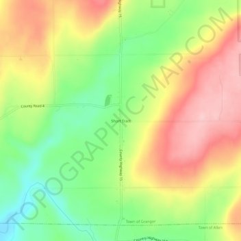
Nombre: Mapa topográfico Short Tract, altitud, relieve.
Altitud media: 518 m
Altitud mínima: 424 m
Altitud máxima: 615 m
Haz una donación
Otros mapas topográficos
Haga clic en un mapa para ver su topografía, su altitud y su relieve.
Haz una donación
Haz una donación
Haz una donación
Village of Alfred
United States > New York > Allegany County
According to the United States Census Bureau, the village has a total area of 1.2 square miles (3.1 km2), all land. A small stream, Kanakadea Creek, flows through the center of the village, then to the Canisteo River, part of the Susquehanna River watershed. The topography is steep hill country, part of the…
Altitud media: 597 m
Haz una donación
Village of Alfred
United States > New York > Allegany County
The elevation of Alfred is about 1,700 feet (520 m) but rises to a high point of 2,355 feet (718 m) at the summit of Jericho Hill just south of the village. The hills greatly affect the weather in the region, which results in quick changes as well as different conditions in neighboring valleys.
Altitud media: 597 m