
Gracias por apoyar a este sitio ❤️
Haz una donación
Haz una donación
Mapa topográfico Grizzly Ridge
Haga clic en el mapa para ver la altitud.
Gracias por apoyar a este sitio ❤️
Haz una donación
Haz una donación
Acerca de este mapa
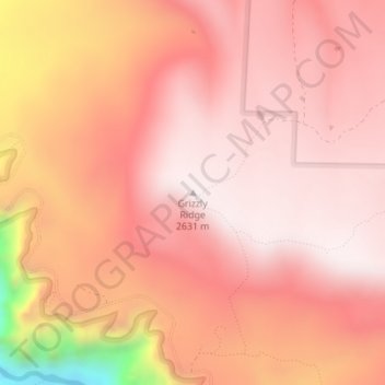
Nombre: Mapa topográfico Grizzly Ridge, altitud, relieve.
Lugar: Grizzly Ridge, Montrose County, Colorado, United States (38.57471 -107.67657 38.57481 -107.67647)
Altitud media: 2,471 m
Altitud mínima: 1,936 m
Altitud máxima: 2,637 m
Gracias por apoyar a este sitio ❤️
Haz una donación
Haz una donación
Otros mapas topográficos
Haga clic en un mapa para ver su topografía, su altitud y su relieve.
Montrose
United States > Colorado > Montrose County
Montrose features a semi-arid Continental climate zone. The town sits on high grasslands in the Uncompahgre Valley of Western Colorado. Snowfall occurs during the winter but is usually short-lived due to the high altitude and abundant sunshine.
Altitud media: 1,803 m