Mapa topográfico Cappel
Mapa interactivo
Haga clic en el mapa para ver la altitud.
Acerca de este mapa
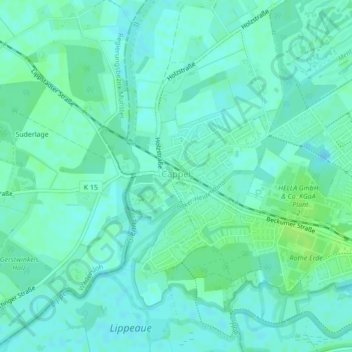
Nombre: Mapa topográfico Cappel, altitud, relieve.
Lugar: Cappel, Lippstadt, Kreis Soest, Nordrhein-Westfalen, Deutschland (51.67099 8.29292 51.69620 8.31528)
Altitud media: 75 m
Altitud mínima: 71 m
Altitud máxima: 81 m
Otros mapas topográficos
Haga clic en un mapa para ver su topografía, su altitud y su relieve.
Dedinghausen
Deutschland > Nordrhein-Westfalen > Kreis Soest > Lippstadt
Dedinghausen, Lippstadt, Kreis Soest, Nordrhein-Westfalen, Deutschland
Altitud media: 89 m
Hellinghausen
Deutschland > Nordrhein-Westfalen > Kreis Soest > Lippstadt
Hellinghausen, Herringhausen, Lippstadt, Kreis Soest, Nordrhein-Westfalen, Deutschland
Altitud media: 75 m
Lipperode
Deutschland > Nordrhein-Westfalen > Kreis Soest > Lippstadt
Lipperode, Lippstadt, Kreis Soest, Nordrhein-Westfalen, Deutschland
Altitud media: 78 m
Eickelborn
Deutschland > Nordrhein-Westfalen > Kreis Soest > Lippstadt
Eickelborn, Lippstadt, Kreis Soest, Nordrhein-Westfalen, Deutschland
Altitud media: 79 m
Hörste
Deutschland > Nordrhein-Westfalen > Kreis Soest > Lippstadt > Hörste
Hörste, Lippstadt, Kreis Soest, Nordrhein-Westfalen, 59558, Deutschland
Altitud media: 84 m
Lipperode
Deutschland > Nordrhein-Westfalen > Kreis Soest > Lippstadt
Lipperode, Lippstadt, Kreis Soest, Nordrhein-Westfalen, 59558, Deutschland
Altitud media: 78 m
Overhagen
Deutschland > Nordrhein-Westfalen > Kreis Soest > Lippstadt
Overhagen, Lippstadt, Kreis Soest, Nordrhein-Westfalen, Deutschland
Altitud media: 79 m