
Mapa topográfico Town of Manlius
Mapa interactivo
Haga clic en el mapa para ver la altitud.
Acerca de este mapa
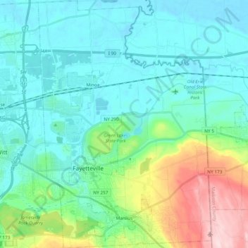
Nombre: Mapa topográfico Town of Manlius, altitud, relieve.
Lugar: Town of Manlius, Onondaga County, New York, United States (42.98525 -76.04249 43.12305 -75.91045)
Altitud media: 179 m
Altitud mínima: 115 m
Altitud máxima: 415 m
Otros mapas topográficos
Haga clic en un mapa para ver su topografía, su altitud y su relieve.
Town of Cicero
United States > New York > Onondaga County
Town of Cicero, Onondaga County, New York, United States
Altitud media: 120 m
City of Syracuse
United States > New York > Onondaga County
City of Syracuse, Onondaga County, New York, United States
Altitud media: 172 m
Hiawatha Lake
United States > New York > Onondaga County > City of Syracuse
Hiawatha Lake, Strathmore, City of Syracuse, Onondaga County, New York, United States
Altitud media: 151 m
Town of Clay
United States > New York > Onondaga County
Town of Clay, Onondaga County, New York, United States
Altitud media: 120 m
Camillus
United States > New York > Onondaga County > Camillus
Camillus, Onondaga County, New York, United States
Altitud media: 177 m
Pompey
United States > New York > Onondaga County > Town of Pompey > Pompey
Pompey, Town of Pompey, Onondaga County, New York, 13138, United States
Altitud media: 450 m
Apulia
United States > New York > Onondaga County > Town of Fabius > Apulia
Apulia, Town of Fabius, Onondaga County, New York, 13020, United States
Altitud media: 409 m