
Gracias por apoyar a este sitio ❤️
Haz una donación
Haz una donación
Mapa topográfico Great Basin National Park
Haga clic en el mapa para ver la altitud.
Gracias por apoyar a este sitio ❤️
Haz una donación
Haz una donación
Great Basin National Park
The park derives its name from the Great Basin, the dry and mountainous region between the Sierra Nevada and the Wasatch Mountains. Topographically, this area is known as the Basin and Range Province. The park is located about 290 miles (470 km) north of Las Vegas and protects 77,180 acres (31,230 ha).
Gracias por apoyar a este sitio ❤️
Haz una donación
Haz una donación
Acerca de este mapa
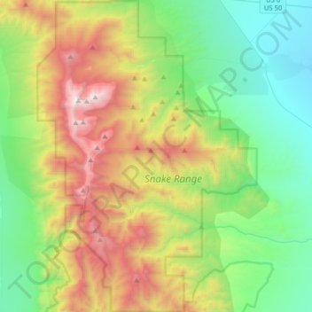
Nombre: Mapa topográfico Great Basin National Park, altitud, relieve.
Altitud media: 2,352 m
Altitud mínima: 1,566 m
Altitud máxima: 3,938 m
Gracias por apoyar a este sitio ❤️
Haz una donación
Haz una donación
Otros mapas topográficos
Haga clic en un mapa para ver su topografía, su altitud y su relieve.